Introduction
The D-RTK 2 High-Precision GNSS Mobile Station from SZ DJI TECHNOLOGY CO., LTD. stands as a flagship solution for ultra-precise satellite positioning in demanding professional environments. Engineered specifically to complement DJI’s RTK-equipped aerial platforms (such as the MG-1P RTK and Phantom 4 RTK), this mobile station delivers centimeter-level accuracy for mission-critical applications in surveying, mapping, agriculture, and engineering fields.
Crucially, the D-RTK 2 (Model: R400BS) has been certified under FCC ID SS3-R400BS1806, confirming its compliance with stringent U.S. electromagnetic interference and radiofrequency emission standards. This certification not only authorizes its legal sale and operation within the United States but also assures users of its adherence to robust safety and reliability benchmarks.
In this article, we’ll dissect the D-RTK 2’s standout features, technical specifications, and advanced wireless technologies. We’ll also present a detailed teardown analysis of its internal components, leveraging insights from FCC documentation and component photographs. Finally, we’ll explore its regulatory standing and highlight practical use scenarios for professionals demanding top-tier GNSS performance.
Key Features & Specifications
The D-RTK 2 High-Precision GNSS Mobile Station is purpose-built for accuracy, reliability, and versatility in the field. Its design reflects a deep integration of advanced satellite technologies, robust wireless communication, and practical usability features.
Key Features
- 16GB Internal Memory: Ample onboard storage for raw GNSS data, logs, and mapping outputs.
- Handheld Mapping Capability (Coming Soon): Anticipated future functionality to enable direct mapping via the device itself.
- Strong Anti-Magnetic Interference: Ensures reliable operation even near high-voltage lines and metallic structures, minimizing data distortion.
- Electronic Bubble for Tilt Measurement: Integrated electronic bubble level allows precise, real-time tilt compensation—critical for maintaining vertical accuracy during field operations.
- Multi-Constellation Support: Simultaneous reception from GPS, Compass, GLONASS, and Galileo systems maximizes satellite coverage, signal reliability, and positioning precision.
- 9-Band Satellite Signal Reception: Enhanced multi-band reception improves accuracy, reduces signal loss, and ensures robust performance in challenging environments.
- DJI Position Service (DPS) Support (Coming Soon): Designed to operate as a network RTK base station, enabling connectivity to cloud-based correction services for scalable deployments.
- Built-in OCUSYNC™ Wi-Fi and Bluetooth: Enables seamless wireless communication with DJI drones, controllers, and other compatible devices for real-time data transmission and control.
- LAN and CAN Data Transmission Links: Wired interfaces ensure reliable, low-latency data sharing and integration with external systems or third-party equipment.
Technical Specifications
- Power Consumption: 12 W (efficient operation for extended field use)
- Positioning Accuracy (RTK):
- Horizontal: 1 cm + 1 ppm (RMS)
- Vertical: 2 cm + 1 ppm (RMS)
- Initialization Reliability: >99.9% (ensures rapid, robust RTK lock)
- Operating Temperature: 0℃ to 45℃
- Dimensions: 168 mm × 168 mm × 1708 mm (including extension rod)
- Battery:
- Provided LiPo battery: 4920 mAh, 37.3 WH, >2 hours standby
- 12S MG-1P battery: >50 hours standby (for extended missions)
- Power Input: 14.4V~25.6VDC, 44.4~58.8VDC (wide range for field adaptability)
- Differential Data Protocols: RTCM2.X/3.X, CMR (broad compatibility with professional GNSS workflows)
- Wi-Fi: Built-in OCUSYNCTM Wi-Fi for high-speed, interference-resistant wireless communications
- Bluetooth: Present for easy device pairing and configuration (details not specified)
These features collectively empower the D-RTK 2 to deliver sub-centimeter accuracy, rapid initialization, and robust connectivity—attributes critical for precision agriculture, surveying, and industrial automation.
Operating Frequencies
The D-RTK 2 High-Precision GNSS Mobile Station (FCC ID SS3-R400BS1806) operates across multiple frequency bands, as detailed in its FCC certification filing:
| Frequency Range (GHz) | Output Power (mW) | FCC Rule Part |
|---|---|---|
| 2.462 | 497 | 15CCC |
| 2.4775 | 492 | 15CCC1.22.412 |
| 5.825 | 55 | 15ECC |
| 5.8445 | 139 | 15ECC2.25.745 |
| 12.4035–2.4775 | 501 | 15CCC1.12.4055 |
| 35.7285–5.8465 | 141 | 15ECC2.15.7305 |
These frequency allocations reflect the device’s support for both 2.4 GHz and 5.8 GHz wireless communications (commonly used for Wi-Fi and drone telemetry), as well as specialized bands for GNSS and RTK signal processing. The output power levels ensure strong, reliable wireless links while maintaining compliance with regulatory emissions limits.
Technology Deep Dive
The D-RTK 2 High-Precision GNSS Mobile Station leverages a sophisticated blend of wireless technologies to deliver seamless connectivity and robust data integrity. Built-in OCUSYNCTM Wi-Fi enables high-throughput, low-latency communication with DJI drones and ground stations, supporting real-time GNSS corrections and telemetry. Bluetooth support simplifies device pairing and configuration in the field, while LAN and CAN interfaces offer wired options for integration with external systems and third-party equipment.
The device’s use of both 2.4 GHz and 5.8 GHz bands allows for adaptive communication strategies, optimizing for range, speed, and interference avoidance in congested RF environments. These frequency choices are industry standards for Wi-Fi and telemetry, ensuring compatibility and reliability even in challenging operational contexts.
High output power in the 2.4 GHz band (up to 501 mW) extends effective working range, while compliance with FCC emission rules ensures safe and interference-free operation alongside other wireless equipment. The multi-band, multi-constellation GNSS receiver design supports precise, low-latency positioning, minimizing errors from multipath and environmental interference.
From the test reports summarized in internal documentation, the D-RTK 2 demonstrates strong electromagnetic compatibility and low RF leakage, reflecting the device’s careful shielding, PCB design, and power management strategies. This attention to detail translates to superior field performance and reliability—even in electromagnetically noisy environments.
In-Depth Internal Component Analysis / Teardown
A closer look inside the D-RTK 2 High-Precision GNSS Mobile Station (Model: R400BS) reveals a meticulously engineered system optimized for high-precision satellite navigation, robust wireless communications, and rugged field reliability. Below, we analyze five key internal component photographs, highlighting the technical sophistication and build quality evident in each view.
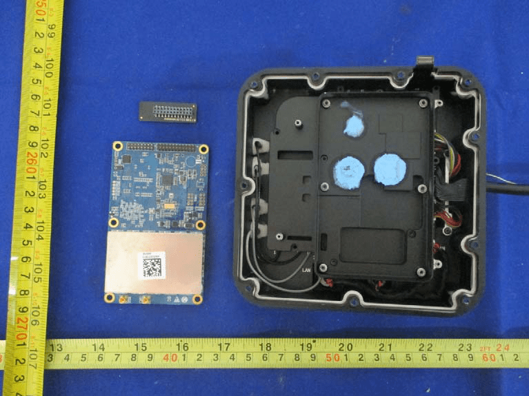
Main PCB with RF Shielding, Connectors, and Housing
Dominating the interior is a custom blue multi-layer PCB featuring a substantial metal shield over the RF section, indicative of sophisticated EMI mitigation for sensitive GNSS receiver circuitry. The shielded compartment likely houses the primary GNSS front-end and baseband processor, crucial for multi-band, multi-constellation satellite reception. Multiple smaller ICs outside the shield hint at dedicated microcontrollers and power management units, supporting the station’s real-time processing and low-noise operation. The board’s dense via stitching and controlled impedance traces underscore a design focused on RF integrity. Coaxial cables routed to the enclosure’s periphery suggest robust antenna connectivity, while the presence of a LAN port and high-density board-to-board connectors enhance modularity and integration options. Large capacitors and inductors point to well-engineered power delivery and filtering, critical for minimizing interference. The inclusion of blue thermal pads and a robust housing further demonstrates a commitment to thermal management and environmental protection, hallmarks of a professional-grade GNSS base station.
High-Density PCB with Main Processor and RF Section
This densely populated PCB exemplifies advanced GNSS hardware engineering. A prominent BGA package—likely the main processor or GNSS engine—anchors the board, surrounded by multiple QFP/QFN components for power regulation, memory, and RF front-end tasks. The black soldermask and gold ENIG finish signify high manufacturing quality, while controlled impedance traces and differential pairs (notably in the upper right) are tailored for high-speed data and RF signal routing. The distinct RF shielded area, with probable U.FL-style connectors, supports external multi-band GNSS antennas, ensuring optimal signal acquisition. A USB Type-C connector offers flexible data and power interfaces, and multiple test points facilitate diagnostics. The modularity, extensive shielding, and robust power architecture reflect a design philosophy centered on signal integrity, low noise, and serviceability—crucial for centimeter-level RTK accuracy.

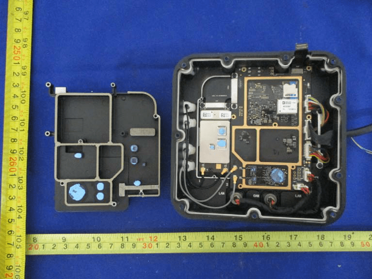
Internal Layout with Shielded GNSS Module and LAN/CAN Interfaces
The internal assembly showcases a well-segregated layout, with a large shielded GNSS module strategically placed for optimal RF performance. Visible connectors for LAN and CAN highlight the station’s integration capabilities with external networks and control systems. The PCB’s multi-layer design, black soldermask, and gold-plated pads reveal careful attention to signal integrity and EMI control, with significant use of via-in-pad and stitching vias. The enclosure itself features gasketed and foam-padded sections for environmental sealing and additional EMI suppression. Blue thermal interface pads indicate proactive thermal management for heat-generating components, while large onboard capacitors and inductors ensure stable power delivery. This ruggedized, modular approach underpins the D-RTK 2’s reliability in harsh field environments and its ability to deliver high-precision, real-time GNSS corrections.
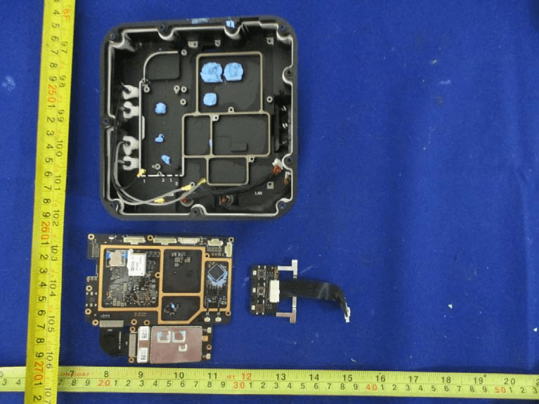
Main PCB and Daughterboard with Antenna Cabling
This view reveals the main PCB and a secondary daughterboard, interconnected via high-density connectors and ribbon cables. The main board hosts a large BGA SoC, shielded RF sections, and a dense array of surface-mount and through-hole components—testament to its complex, multi-domain design. Multiple coaxial cables connect to the board, supporting GNSS and possibly other RF functionalities, with all antennas cabled rather than PCB-integrated for maximum flexibility and performance. The enclosure’s compartmentalized, gasketed structure enhances EMI isolation and environmental durability. Power regulation is handled by large inductors and capacitors, with multiple domains likely supporting digital, analog, and RF circuits. Crystals and test points further indicate the board’s readiness for high-precision timing and diagnostics. Overall, this configuration exemplifies a well-balanced approach to modularity, signal integrity, and serviceability.
PCB with RF, Power, and High-Speed Connectors
This compact, blue PCB is densely populated on the left side with QFP and QFN/BGA packages, likely fulfilling microcontroller, RF front-end, and power management roles. The right side features a large multi-pin connector for system integration, supported by two probable U.FL RF connectors for external antenna interfacing. Numerous vias, including via-in-pad and differential pair routing, suggest a sophisticated multi-layer structure aimed at maximizing RF and signal integrity. The presence of a crystal oscillator provides a high-precision clock for GNSS operations. Robust grounding, test points, and unpopulated headers reflect a design attentive to EMI control, diagnostics, and future expandability. This PCB embodies the technical rigor required for reliable, high-precision GNSS/RTK functionality in a modular, serviceable form factor.

Regulatory Insights & FCC Filing
The D-RTK 2 High-Precision GNSS Mobile Station (Model: R400BS), registered under FCC ID SS3-R400BS1806, has been rigorously tested to meet U.S. standards for radiofrequency emissions, electromagnetic compatibility, and user safety. This FCC certification is a legal prerequisite for sales and operation within the United States, confirming that the device will not cause harmful interference to licensed communications or exceed permissible RF exposure limits.
FCC filings encompass a comprehensive suite of documentation, including test reports for RF exposure and electromagnetic compatibility, detailed internal and external photographs, user manuals, block diagrams, and schematics. These documents provide transparency into the device’s design, operational parameters, and compliance with regulatory standards.
Insights from the user manual and test reports highlight the D-RTK 2’s advanced multi-constellation GNSS receiver, robust anti-magnetic interference measures, and versatile connectivity options. The internal documentation underscores the manufacturer’s focus on shielding, power management, and modularity—critical factors for maintaining performance in real-world, interference-prone environments. The successful certification under FCC ID SS3-R400BS1806 assures buyers and operators that the D-RTK 2 is engineered for both reliability and regulatory compliance.
Potential Use Cases & Target Audience
The D-RTK 2 High-Precision GNSS Mobile Station is meticulously tailored for professionals and organizations where centimeter-level accuracy and robust wireless connectivity are non-negotiable. Its advanced features and rugged design open up a spectrum of high-value applications:
-
Aerial Surveying & Mapping with DJI RTK Aircraft: Operators of DJI drones such as the MG-1P RTK and Phantom 4 RTK can leverage the D-RTK 2 as a mobile base station, achieving real-time kinematic (RTK) corrections for ultra-precise mapping, photogrammetry, and volumetric analysis. The built-in OCUSYNCTM Wi-Fi ensures seamless, low-latency data transmission between the drone and base station, even in complex or remote environments.
-
Precision Agriculture & Farm Planning: Agricultural engineers and farm managers can deploy the D-RTK 2 for automated guidance of tractors, drones, and implements. Its strong anti-magnetic interference capabilities ensure reliable operation near large metallic structures and high-voltage lines, while multi-band reception guarantees accuracy in open fields and challenging terrains alike.
-
Civil Engineering & Construction Site Layout: Surveyors and site engineers benefit from the D-RTK 2’s rapid RTK initialization, electronic bubble tilt compensation, and robust LAN/CAN interfaces. These features enable efficient, error-free site layout, machine control, and progress monitoring—minimizing downtime and rework.
In all these scenarios, the D-RTK 2’s modular connectivity, rugged build, and regulatory compliance make it an indispensable tool for professionals demanding uncompromising GNSS precision.
Conclusion
The D-RTK 2 High-Precision GNSS Mobile Station from SZ DJI TECHNOLOGY CO., LTD. stands as a benchmark in professional GNSS positioning solutions. Its advanced multi-constellation receiver, robust wireless and wired interfaces, and rugged design deliver reliable, centimeter-level accuracy in the most demanding field environments. FCC certification under ID SS3-R400BS1806 affirms its compliance with U.S. regulations, ensuring safe, interference-free operation. Whether deployed for aerial mapping, precision agriculture, or engineering surveys, the D-RTK 2 exemplifies cutting-edge GNSS technology, empowering users to achieve new heights in accuracy and operational efficiency.